
Geotagging your Travels
Geotagging is the process of adding geographical metadata to various media, such as photos. I use an iPhone app called Geotag Photos Pro to record GPS data that will later be added to photos taken from my DSLR. It records the GPS, time, and date at a specified interval. Later you can use software on your computer to match the approximate time and date to a GPS location. That GPS location will be added to the metadata of the photo.
On a previous trip from New York City to Cincinnati, by way of Amtrak’s Cardinal, I decided to geotag the entire ride. Every two minutes the application recorded the GPS location of the train. At the conclusion of the trip, I exported the GPS data as a GPX file. Using a site called GPS Visualizer I was able to add the GPS data to Google maps.

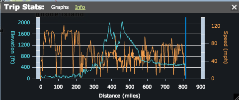
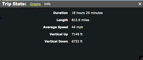
For even more detail I added this trip to Everytrail.com. Which allows you to share trips and view stats, such as average speed.
I plan to use this on my upcoming cycling trip from Prague to Vienna.